David Givens, an archaeologist in Jamestown, Virginia, is peering into a pit on a hot, cloudless afternoon in July. A year earlier, his team had been excavating at this spot and chanced upon a circle of bricks indicating a 17th-century well. He’s excited about what it might yield when they dig down into it: pieces of clothing and shoes, seeds, animal bones and other everyday items thrown away as trash, offering important clues to life in the colony.
Today, though, all that can be seen is a crab scuttling across the pit. “That’s not supposed to be there,” he says.
The crab is a small sign of the bigger problem facing Jamestown, site of the first permanent English settlement in North America: Water is everywhere it’s not supposed to be. Low-lying Jamestown Island is flooding more frequently than it used to. On one side of what remains of the 1607 fort and adjacent town — Virginia’s first capital — the island’s swamp is advancing. On the other side, the tidal James River batters the shoreline.
“What we’re seeing is an exponential increase in the impacts of climate change that could have a good deal of this site underwater within the next 25 years, let alone the next 50,” says James Horn, president and chief operating officer of the Jamestown Rediscovery Foundation (JRF), the nonprofit that shares administration of the island with the National Park Service.
Four centuries ago, the Virginia Company in London sent ships across the Atlantic with orders to found a settlement and search out gold, silver and a sea route to Asia. The leaders of the expedition sailed upriver from what’s now the city of Norfolk, Virginia, until they came to a spit of land protected by water on three sides (it wasn’t yet an island).
The peninsula where they set up camp belonged to the Paspahegh people, who defended it. Relations between the settlers and tribes fluctuated from open warfare to tense peace and back again during Jamestown’s grim early years, when many colonists died from disease, starvation or injuries sustained in fighting. The winter of 1609 to 1610, known as the “starving time,” drove people to eat cats, dogs, rats and shoe leather. Skeletal remains of a teenage English girl found in 2012 showed evidence of cannibalism. It was only the discovery of a cash crop — tobacco — that staved off the colony’s collapse.
Jamestown is probably best known in connection with Pocahontas, daughter of the regional leader Wahunsunacock, or Powhatan. She visited the settlers, brought them food and later married one, John Rolfe. While a romanticized version of the Pocahontas story has become one of the nation’s founding myths, Jamestown’s legacy also includes early treaties that put Native peoples under the power of the English crown and restricted their access to certain lands.
Jamestown “is the jumping-off point in many ways for what happened in the future, in terms of the development of the United States’ Indian policy, the way that the United States expands across the West. It all starts there,” says Ashley Spivey, a Virginia-based anthropologist who is a member of the Pamunkey Indian Tribe, descended from the Powhatan chiefdom.
The colony left another contradiction at the root of the country’s identity: It was both the birthplace of representative democracy in colonial America and the birthplace of American chattel slavery. Virginia’s General Assembly was founded in Jamestown and met for the first time in July 1619. A few weeks later, ships carrying captives from Angola came to Point Comfort, at the mouth of the James River, and the sailors sold the Africans into bondage. At least one of them — a woman whose name is recorded as Angelo or Angela — was taken to Jamestown, and more in subsequent years.
Initially, their legal status was uncertain. Through the second half of the 17th century, Virginia’s assembly codified laws that, in the words of an exhibit in Jamestown’s archaeology museum, “entrenched slavery and racism and circumscribed the lives of countless African Americans and Indian peoples.”
In short, it’s hard to think of anywhere in the US that tells a more important and complex story of the country’s beginnings. And it’s disappearing.
Sea level rise poses a greater threat to the Hampton Roads region of Virginia than anywhere else on the East Coast. The waters around Jamestown Island are 1.6 feet higher than a century ago and are projected to rise another three feet by 2075. That would inundate 14 out of the 22.5 acres that make up the part of the island managed by JRF, where heritage areas such as the fort and a 17th-century church tower are located.
The Park Service oversees the rest of the 1,500-acre island, which is likewise dotted with archaeological sites that are now at risk, says Dwayne Scheid, division lead of resource stewardship and science for Colonial National Historical Park. Scheid notes that subsidence in the area is significant. “So not only is the sea level rising, the island is sinking. Which just compounds the issue.”
Jamestown has been battling the elements for a long time. Erosion on the island’s western shore was bad enough by the turn of the 20th century that the US Army Corps of Engineers built a seawall in 1901. The wall weakened over time, so in 2022 JRF reinforced it with 98,000 tons of granite boulders intended to slow down and dissipate the energy from waves during storms.
That was the crucial first step in a resiliency plan the group is raising funds to carry out. But holding off the river in front of the fort made them acutely conscious of the serious danger behind it: the swamp. The trees that have held the swamp back are increasingly toppling in storms, their roots weakened by rising, brackish groundwater. As the river also rises and rainfall increases, all that water has nowhere to go except the remaining dry land. A solitary drainage pipe installed in the 1950s is now silted up. JRF wants to install new drainage and build pumping stations as well as a berm to protect historic areas against flooding.
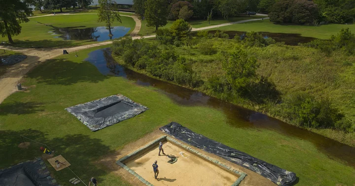
Recently, a strip of marsh grass sprang up within 20 feet of an area where Givens’ team is digging, looking for traces of what may be a section of the town previously unknown to historians. The area could contain burials; since it is some distance from the fort and church, those burials would possibly be of marginalized people such as indentured servants or enslaved Africans. The archaeologists are in a race against time to discover as much as they can as fast as they can, to stay ahead of the water.
Crouching over one of the pits, archaeologist Sean Romo points to dark gray soil that’s saturated with groundwater. Water intrusion changes the chemistry of the soil and can damage artifacts and dissolve bones. “So we may lose information if the water continues to rise,” Romo says.
Building a flood berm and drainage pumps and elevating roads, pathways and low-lying buildings will cost an estimated $41 million. Horn stresses that Jamestown can’t wait on lengthy approvals processes or far-off funding cycles: Delay will only compound the dangers to the site. If successful, the project will buy Jamestown 50 to 75 more years — probably. The resiliency plan is based on an intermediate scenario of tidal inundation, not a severe one.
“Future retreat from the island may be considered as the rate of sea level rise increases and the site becomes unsafe to occupy,” that plan notes. There’s a future, Horn acknowledges, in which Jamestown Island is an archipelago and glass-bottomed boats ply the water around and above it. But to him it’s unthinkable that such a valuable site could just be allowed to slip beneath the waves.
Jamestown, at least, has name recognition and a steady flow of tourists that help draw attention to its plight. Other, less high-profile cultural heritage sites nearby face climate perils too. Werowocomoco, on the York River, was once the center of the Powhatan chiefdom. It’s contending with erosion, groundwater intrusion, sinking and flooding, says Spivey, who is working with the Park Service and Virginia tribes to develop an archaeological resources management plan for the site. If the physical traces of its history are washed away, they’ll be gone forever: “The archaeological record is a non-renewable resource,” Spivey says.
On Jamestown Island, Scheid and his Park Service coworkers are developing a matrix to rate archaeological sites by their significance and climate threat level, to help prioritize funding requests. “It’s challenging, because I know there’s more there that we’re not going to uncover with the amount of time-slash-amount of money we have,” he says.
Meanwhile, JRF’s Givens is adapting his working methods to a landscape rapidly being reshaped. Searching for a centuries-old buried road this summer took him and colleagues out into a newly marshy area where ground-penetrating radar wouldn’t work. So they improvised, mounting sonar equipment onto a pair of kayaks, and found what they believe is the road.
It’s a striking example of how Jamestown’s present as well as its future are, in Givens’ words, “both terrestrial and submerged.”